Fiordland & Te Wāhipounamu — A World Heritage Road Trip
Fiords, glaciers, and alpine valleys — see New Zealand’s entire southwest wilderness as one journey.
Conquering Te Wāhipounamu
···
Te Wāhipounamu—meaning “place of the greenstone” in Māori—is one of New Zealand’s greatest treasures. Covering about 10% of the South Island—around 26,000 km² (10,000 mi²)—and spanning four national parks in the island’s southwest, this vast wilderness is protected as a UNESCO World Heritage Site. It’s a place where glaciers carve through valleys, ancient rainforests shelter rare birds, and rugged coastlines meet soaring alpine peaks.
Fiordland is the largest and wildest of New Zealand’s national parks, more than 12,600 km² (4,860 mi²). It forms the heart of Te Wāhipounamu, stretching across the island’s southwest. For most travellers it means a day trip to Milford or Doubtful Sound, but the park stretches far beyond, with trails, lakes, and remote corners that reward more time.
This guide is designed to help travelers plan a successful road trip through Te Wāhipounamu by bringing together what makes the region so unique and the practical details needed for a smooth journey.
UNESCO World Heritage — Te Wāhipounamu (Fiordland & the South West)
Why UNESCO Recognizes Te Wāhipounamu
Interested in more World Heritage Sites? Explore our World Heritage Sites search.
What “World Heritage” Really Means
UNESCO’s World Heritage list protects places of “Outstanding Universal Value” for all humanity. Te Wāhipounamu qualifies as one of the world’s last great temperate wildernesses, where mountains, glaciers, and rainforests endure in near-pristine form.
Why it matters: Fewer than a quarter of World Heritage Sites are listed for natural criteria, and even fewer are this large and unmodified. Seeing Te Wāhipounamu isn’t just sightseeing — it’s experiencing one of the planet’s great natural landscapes.
Why a Road Trip?
A road trip is the only way to truly grasp how these majestic landscapes connect, from Fiordland’s sheer, glacially carved walls to the wide, branching rivers of Mount Aspiring. With a car, you can witness in real-time how the dense rainforest of the West Coast gives way to the ancient ice of Franz Josef and Fox glaciers, as the Southern Alps block the moist coastal winds and create the vast, sun-baked expanse of the Mackenzie Basin. Each turn offers a sudden, stunning shift in mood and scenery, inviting you to pull over on a whim. The freedom of the open road lets you witness the entire southwest spine of New Zealand unfold at your own pace, one unforgettable view at a time.
Essential Pre-Trip Planning
When to Go
- Summer (Dec–Feb): Warm, long days (19–23ºC), best for hiking and outdoor activities, but also busiest and most expensive.
- Autumn (Mar–May): Fewer crowds, mild weather, and spectacular foliage around places like Arrowtown and Wanaka.
- Winter (Jun–Aug): Great for skiing and glacier tours, but some roads are icy and require extra caution.
- Spring (Sep–Nov): Lush landscapes and fewer tourists, though weather can be unpredictable.
Driving and Vehicle Rules
- Drivers must be at least 21 with a valid license (in English or with a certified translation/IDP).
- Driving is on the left, and roads are often narrow, winding, and slower than maps suggest.
- Expect one-lane bridges, steep alpine roads, and gravel stretches in rural areas.
Entry Requirements
Travelers from visa-waiver countries (like the U.S.) don’t need a visa for stays under 90 days, but must apply for a New Zealand Electronic Travel Authority (NZeTA) before arrival. The NZeTA is valid for two years and multiple entries.
Road Challenges to Expect
- Homer Tunnel (Milford Sound route): A one-way tunnel that adds time and requires patience in traffic.
- Crown Range Road (Queenstown–Wanaka): New Zealand’s highest sealed alpine pass—steep, scenic, and demanding. Chains are required in winter. Safer alternative: State Highway 6.
- General driving pace: Even short distances can take hours, especially on alpine or coastal routes. Always allow more time.
Suggested Itinerary: World Heritage Road Trip, a Journey of Fire and Ice
This loop begins in Queenstown and ends in Christchurch (or back in Queenstown), linking four national parks — Fiordland, Mount Aspiring, Westland Tai Poutini, and Aoraki/Mount Cook — into one journey of fiords, glaciers, alpine passes, and turquoise lakes.
The route first heads into Fiordland, where the road ends at Milford Sound before returning via Te Anau; because of Fiordland’s vast size, it’s worth allowing extra time here beyond just a quick visit. From there, the trip continues east through Mossburn and the Crown Range to Wanaka, then west across Haast Pass to the wild West Coast. The final stretch crosses the Southern Alps into the Mackenzie Basin, finishing among the peaks and turquoise lakes of Mount Cook and Tekapo.
The circuit can be done in a week, but more time opens opportunities for hikes, cruises, and exploring Fiordland’s quieter corners.
Trip at a Glance
- Queenstown-Milford Sound (1–2 nights) : Te Anau (overnight)—Gateway to Fiordland, preparation point for Milford Sound. Famous fiord with waterfalls, cliffs, dolphins, and scenic cruises.
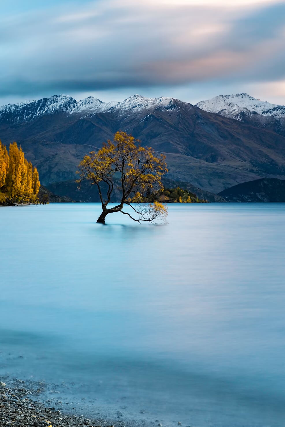
- Wanaka (1–2 nights): Stunning lakeside town at the foot of Mount Aspiring National Park, ideal for hikes and relaxation.
- West Coast Glaciers (1–2 nights) : Visit Franz Josef and Fox Glaciers. Heli-hikes provide close-ups, while valley walks offer viewpoints. Franz Josef township also has hot pools.
- Arthur’s Pass : Scenic crossings through the Southern Alps, with walking trails and viewpoints.
- Christchurch(1–2 nights) : South Island’s largest city with gardens, cafes, a gondola, and a revitalized arts scene.
Booking Tip: Accommodation in Te Anau, Franz Josef/Fox, and Mount Cook Village often sells out months ahead in summer — plan early, especially if you need consecutive nights.
Road Trip Expanded
Day 1–2 — Enter Fiordland: Milford Sound and Beyond
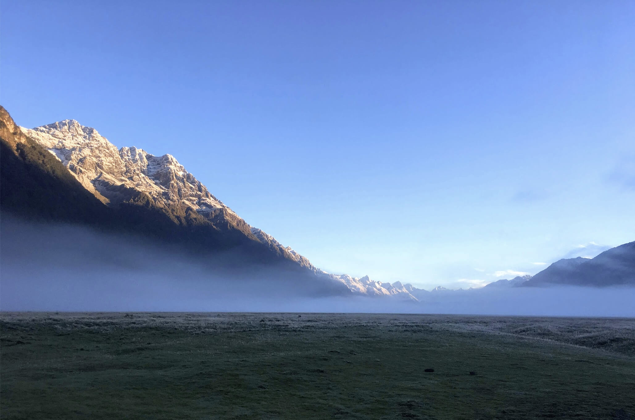
From Queenstown, drive south along stunning Lake Wakatipu before turning west toward Te Anau, the gateway to Fiordland National Park. Base yourself here for two nights to properly experience this vast and dramatic region. The Milford Road is a scenic journey, winding through the Eglinton Valley past mirror lakes and swing bridges, before reaching the mountains via Homer Tunnel.
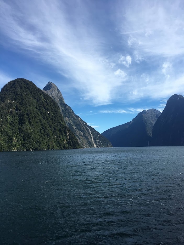
At Milford Sound, steep cliffs rise a kilometer from the water, waterfalls cascade from cloudy heights, and dolphins often accompany cruises. For a quieter, more remote experience, consider the longer boat-and-bus trip to Doubtful Sound, where silence is rarely broken except by the wind and wildlife.
Highly Recommended: Fiordland is nearly twice the size of Yellowstone National Park, and deserves more than a quick day trip. Most travelers fit Milford or Doubtful Sound into a single day, but adding an extra night or two in Te Anau lets you explore quiet lakes, day hikes, and remote fiords accessible only by boat or air. Or simply relax and watch the weather transform the landscape’s waterfalls and cliffs.
Drive: Queenstown → Te Anau, 2 hrs (170 km / 106 mi); Te Anau → Milford Sound, 2 hrs (120 km / 75 mi).
Overnight: Te Anau (2 nights minimum recommended).
Day 3 — Te Anau to Wanaka via Crown Range
Retrace the route back toward Queenstown, then take the Crown Range Road — New Zealand’s highest fully paved (sealed) pass — with spectacular switchbacks and sweeping views over the Wakatipu Basin and surrounding mountain ranges. The road climbs dramatically, offering memorable scenic lookouts along the way, and connects the area near Queenstown to Wanaka via this alpine route. Wanaka is a relaxed lakeside town at Mount Aspiring National Park's doorstep, perfect for evening strolls and hikes. If time permits, tackle the Rob Roy Glacier track: a beautiful walk through beech forest and across swing bridges leading to hanging icefalls and waterfalls.
Drive: Te Anau → Wanaka, 4.5 hrs (290 km / 180 mi).
Overnight: Wanaka.
Day 4 — Over Haast Pass to West Coast Glaciers
Heading north from Lake Hawea, the road narrows and the forest closes in. Haast Pass features several striking natural pauses: ice-blue pools reached by swing bridge, Fantail Falls' shimmering curtain, and Thunder Creek’s dramatic plunge beside the road. Emerging from the mountains, the ocean air hints at the wild Tasman coast lying ahead. The final stretch runs along the untamed coast, with surf on one side and rainforest on the other, until you reach the glacier towns of Franz Josef or Fox Glacier.
Drive: Wanaka → Franz Josef, 4.5–5 hrs (285 km / 177 mi).
Overnight: Franz Josef or Fox Glacier.
Day 5 — Explore Glacier Country
Spend the day in the unique setting where glaciers descend into temperate rainforest. Take walks to the viewpoints at Franz Josef and Fox Glaciers or opt for a heli-hike—a helicopter flight that drops you atop the glacier to hike across ice formations with expert guides for a close-up, adventurous experience on the ice. If the evening’s weather permits, visit Lake Matheson near Fox—its still waters famously mirror Aoraki/Mount Cook against the sunset, creating a nearly surreal scene.
Overnight: Franz Josef or Fox Glacier.
Day 6 — Cross the Southern Alps to Aoraki/Mount Cook
Leaving the rainforest behind, the landscape opens across tawny plains with snow-capped peaks on the horizon. Drive north before turning inland across the Alps into the Mackenzie Basin. Follow Lake Pukaki’s milky blue waters to Mount Cook Village, with New Zealand’s highest peak looming ahead. The Hooker Valley Track is a must: a 3-hour walk featuring swinging bridges, rushing rivers, and an alpine lake dotted with icebergs below Aoraki’s summit.
Drive: Franz Josef → Mount Cook Village, ~6 hrs (420 km / 260 mi).
Overnight: Mount Cook Village.
Day 7 — Lake Tekapo and Return
End the journey with a stop at Lake Tekapo, known for its stunning turquoise waters and the picturesque stone Church of the Good Shepherd. Tekapo is also part of a Dark Sky Reserve, making it a perfect spot for stargazing under crystal-clear skies. From here, continue to Christchurch, or loop back south to Queenstown to complete the circuit.
Drive: Mount Cook → Tekapo, 1 hr (105 km / 65 mi); Tekapo → Christchurch, 3 hrs (225 km / 140 mi).
What is a Dark Sky Reserve? A Dark Sky Reserve is a protected area with minimal light pollution, preserving exceptionally clear and dark night skies. This allows spectacular stargazing, where stars, planets, and the Milky Way are vividly visible. The Aoraki Mackenzie Reserve in New Zealand is one of the world’s best-known Dark Sky Reserves, offering an unforgettable night sky experience far from city lights.
Planning and Booking Tips
- This entire loop covers roughly 1,400 km (870 miles). Build extra time into your schedule for weather delays, road conditions, and unplanned stops.
- Accommodation in high-demand areas like Te Anau, Franz Josef/Fox, and Mount Cook Village often sells out months ahead in summer — book early, especially for consecutive nights.
- Enjoy this trip unrushed, allowing for detours, hikes, cruises, and quiet moments to absorb the breathtaking landscapes.
Where to Stay
- Hotels and Motels: Comfort and convenience, often with spectacular views (e.g., Hermitage Hotel in Mount Cook).
- Holiday Parks: Ideal for campervans, offering communal kitchens, showers, and powered sites.
- DOC Campsites: Affordable camping options—basic to standard—but often require advance booking.
- Freedom Camping: Restricted and heavily regulated. Only certified self-contained vehicles can stay in designated spots. Illegal camping risks fines.
Key Takeaways
Te Wāhipounamu is a living showcase of glaciers, mountains, forests, and wildlife at their most dramatic. But a successful road trip here means respecting the land, taking time to travel safely, and planning with care. The reward is an experience that is breathtaking, humbling, and unforgettable.